![](/images/other/stat-length.png)
![Tour Wandern La Garde-Freinet - Route des crêtes - La Garde-Freinet - Photo](https://media.geolcdn.com/t/1900/400/d2d34c83-0d7b-4d7d-a492-1825522e03a7.jpg&format=pjpeg&maxdim=2)
Route des crêtes - La Garde-Freinet
LBarel
Benutzer
![Länge](/images/other/stat-length.png)
![Maximale Höhe](https://static1.geolcdn.com/siteimages/upload/files/1508320355ic_sort_altitude_max_24dp.png)
![Positive Höhendifferenz](https://static1.geolcdn.com/siteimages/upload/files/1508320355ic_sort_den_pos_24dp.png)
![Km-Effort](/images/other/stat-length.png)
![Min. Höhe](https://static1.geolcdn.com/siteimages/upload/files/1508320355ic_sort_altitude_min_24dp.png)
![Negative Höhendifferenz](https://static1.geolcdn.com/siteimages/upload/files/1508320355ic_sort_den_neg_24dp.png)
![Boucle](https://static1.geolcdn.com/siteimages/upload/files/16400158638029165_repeat_loop_refresh_sync_direction_icon.png)
![Wandern](https://static1.geolcdn.com/sitytour/trail-icons/101.png)
2h35
Schwierigkeit : Sehr leicht
![Scannen Sie diesen QR-Code, um die Tour in der SityTrail-Anwendung zu öffnen](https://capi.geolives.com/qq0zvz2zws4bq2lad0pu/sitytour/trails/2534710/qr.png?size=200)
Kostenlosegpshiking-Anwendung
Über SityTrail
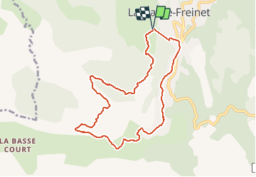
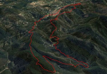
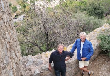
Tour Wandern von 9,5 km verfügbar auf Provence-Alpes-Côte d'Azur, Var, La Garde-Freinet. Diese Tour wird von LBarel vorgeschlagen.
Beschreibung
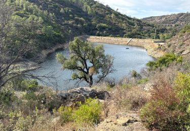
Au départ du parking de la Croix, cette balade facile emprunte la route des Crêtes. Vue sur la plaine des Maures et traversée d'une belle châtaigneraie.
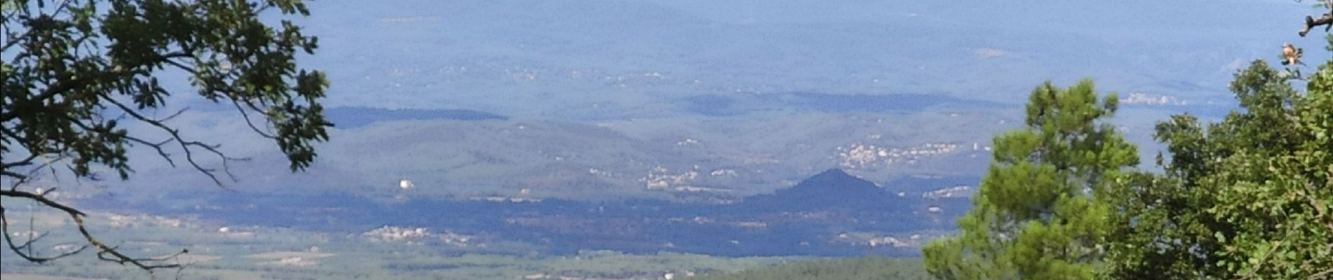
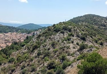
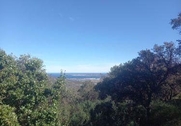
La deuxième partie remonte vers le GR9 et donne à voir les lac des Escarcets et le Luc/Le Cannet des Maures au loin. Enfin la 3e suit le GR9, petite route sinueuse jusqu'à la Garde-Freinet avec une vue imprenable sur le golfe de Saint-Tropez.
Ort
Kommentare
Touren in der Umgebung
![Tour Wandern La Garde-Freinet - SityTrail - Fort Freinet-la Garde-Freinet-02-06-23 - Photo](https://media.geolcdn.com/t/375/260/ce777452-e991-4230-8a3a-fe54e13fa23c.jpg&format=jpg&maxdim=2)
![Wandern Wandern](https://static1.geolcdn.com/sitytour/trail-icons/101.png)
Wandern
![](/images/other/stat-length.png)
![](https://static1.geolcdn.com/siteimages/upload/files/16400158638029165_repeat_loop_refresh_sync_direction_icon.png)
![Tour Wandern Le Cannet-des-Maures - lac des escarcets - Photo](https://media.geolcdn.com/t/375/260/ext.jpg?maxdim=2&url=https%3A%2F%2Fstatic1.geolcdn.com%2Fsiteimages%2Fupload%2Ffiles%2F1553511878bg_sport_marche.png)
![Wandern Wandern](https://static1.geolcdn.com/sitytour/trail-icons/101.png)
Wandern
![](/images/other/stat-length.png)
![](https://static1.geolcdn.com/siteimages/upload/files/16400158638029165_repeat_loop_refresh_sync_direction_icon.png)
![Tour Wandern La Garde-Freinet - La Mourre, La Garde-Freinet-22-05-24 - Photo](https://media.geolcdn.com/t/375/260/d83ec998-34f1-4f9a-9ad9-3f2fca5f6ed5.jpg&format=jpg&maxdim=2)
![Wandern Wandern](https://static1.geolcdn.com/sitytour/trail-icons/101.png)
Wandern
![](/images/other/stat-length.png)
![](https://static1.geolcdn.com/siteimages/upload/files/16400158638029165_repeat_loop_refresh_sync_direction_icon.png)
![Tour Wandern La Garde-Freinet - Garde freinet rev - Photo](https://media.geolcdn.com/t/375/260/7c0f54ba-5dae-4e90-b68b-91a753a14687.jpg&format=jpg&maxdim=2)
![Wandern Wandern](https://static1.geolcdn.com/sitytour/trail-icons/101.png)
Wandern
![](/images/other/stat-length.png)
![](https://static1.geolcdn.com/siteimages/upload/files/16400158638029165_repeat_loop_refresh_sync_direction_icon.png)
![Tour Zu Fuß La Garde-Freinet - Fort Freinet-la Garde-Freinet-02-06-23 - Photo](https://media.geolcdn.com/t/375/260/a55d6a88-f340-481f-bdaf-db37fcbe61e6.jpg&format=jpg&maxdim=2)
![Zu Fuß Zu Fuß](https://static1.geolcdn.com/sitytour/trail-icons/100.png)
Zu Fuß
![](/images/other/stat-length.png)
![](https://static1.geolcdn.com/siteimages/upload/files/16400158638029165_repeat_loop_refresh_sync_direction_icon.png)
![Tour Wandern Grimaud - Grimaud - le pont des fées - Mont Roux 11.3.23 - Photo](https://media.geolcdn.com/t/375/260/b931d4cf-3c48-45c3-9286-94f622997895.jpg&format=jpg&maxdim=2)
![Wandern Wandern](https://static1.geolcdn.com/sitytour/trail-icons/101.png)
Wandern
![](/images/other/stat-length.png)
![](https://static1.geolcdn.com/siteimages/upload/files/16400158638029165_repeat_loop_refresh_sync_direction_icon.png)
![Tour Wandern La Garde-Freinet - les roches blanches - La Garde Freinet - Photo](https://media.geolcdn.com/t/375/260/f87c2506-3a8b-4a88-ba3e-49e9b5d399bc.jpg&format=jpg&maxdim=2)
![Wandern Wandern](https://static1.geolcdn.com/sitytour/trail-icons/101.png)
Wandern
![](/images/other/stat-length.png)
![](https://static1.geolcdn.com/siteimages/upload/files/16400158638029165_repeat_loop_refresh_sync_direction_icon.png)
![Tour Wandern La Garde-Freinet - la Garde Freinet-Les Roches Blanches - Photo](https://media.geolcdn.com/t/375/260/ext.jpg?maxdim=2&url=https%3A%2F%2Fstatic1.geolcdn.com%2Fsiteimages%2Fupload%2Ffiles%2F1553511878bg_sport_marche.png)
![Wandern Wandern](https://static1.geolcdn.com/sitytour/trail-icons/101.png)
Wandern
![](/images/other/stat-length.png)
![](https://static1.geolcdn.com/siteimages/upload/files/16400158638029165_repeat_loop_refresh_sync_direction_icon.png)
![Tour Wandern Grimaud - Grimaud - Photo](https://media.geolcdn.com/t/375/260/d7d06650-601d-401f-a80f-38d8fa73f2de.jpg&format=jpg&maxdim=2)
![Wandern Wandern](https://static1.geolcdn.com/sitytour/trail-icons/101.png)
Wandern
![](/images/other/stat-length.png)
![](https://static1.geolcdn.com/siteimages/upload/files/16400158638029165_repeat_loop_refresh_sync_direction_icon.png)